The Yungay disaster Life in the Andes has always been dangerous, squeezed between the Scylla and Cha
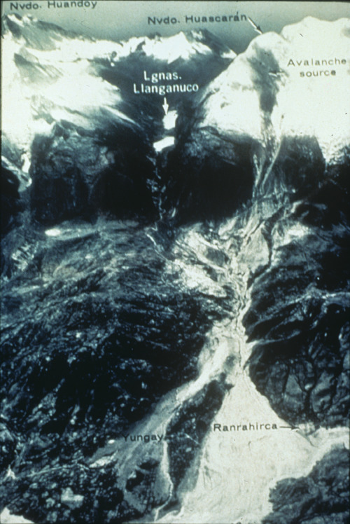
The Yungay disasterLife in the Andes has always been dangerous, squeezed between the Scylla and Charybdis of volcano and earthquake everyone along the mountain chain lives by nature’s consent. At 1523 on the last day of May in 1970, while most of the inhabitants of Yungay were tuned in to the Brazil Italy world cup match on their radios, a fault ruptured offshore in the subduction zone off Peru and shook for 45 seconds at magnitude 8. The Nazca plate is sliding under the South American one and thrusting up the mountain chain every time the friction releases and the continental plate springs back upwards from its tectonic downwarp.Yungay sits at a height of 2,500 metres, below the peak of the country’s highest mountain, Huascaran (around 6,700 metres, the average of the 2 peaks) in the Cordillera Blanca. Ironically it is the place on Earth with the lowest gravity, but such as there is was certainly enough for what followed. Eight years previously two American scientists had reported a glacier undermining a massive slab of rock high up the mountain that might fall on the town, though the authorities downplayed the report.The quake dislodged millions of tons of snow, rock and ice that fell down the mountain’s north face towards the town, gathering more material as it fell. By 1526 it had travelled the 15km to Yungay (at 300or so kph) and obliterated it along with nearby Ranrahirca, leaving nothing but the cemetery on a small hill at the edge of town. It was the country’s worst recorded disaster, and the deadliest known avalanche in history, with casualty estimates ranging from 75-80,000 dead 25,000 missing under the mud, including most of the inhabitants of the town (some 400 survived out of 25,000). Over a million were left homeless.The town was rebuilt nearby, and the original site has been declared a national cemetery, and excavation prohibited. Since 2000, May 31 has been observed as Natural Disaster Education and Reflection Day and schools practice their earthquake drills.LozImage credit: Yungay Viejo (2500 m) as seen from the cemetery hill. The light shaded area shows the location of the landslide (ice, mud, debris avalanche) on 31.05.1970, caused by an earthquake, in which a part of the western flank of Huascaran Norte broke (6652 m). Yungay Nuevo is behind the shaded area in the center. Uwebart 2: Enrique Falcon 3: G. Pflafker. U.S. Geological Surveyhttp://1.usa.gov/1B9fx0Khttp://bit.ly/1lIyu9Shttp://bit.ly/1YanuTKhttp://bit.ly/1NR5rv3 -- source link
Tumblr Blog : the-earth-story.com
#science#history#disaster#yungay#andes#brazil#geology#avalanche#mountain#landslide#earthquake#yungay nuevo


