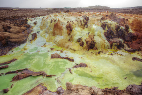
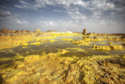
Dallol Volcano In northern Ethiopia, a rift zone, bounded by normal faults on both sides, runs paral
Dallol VolcanoIn northern Ethiopia, a rift zone, bounded by normal faults on both sides, runs parallel to the Red Sea. It is being pulled apart by the same tectonic forces that formed the Red Sea and shows some of the features that would probably have been found in the Red Sea just before it opened; a mixture of lowlands, salt flats, and volcanic activity. That rift is known as the Danakil depression.The Danakil Depression is at very low elevation; its lowest point sits about 120 meters below sea level. Due to this low elevation, salt water from the nearby Red Sea occasionally has broken through to flood the depression, but volcanoes cut off the most recent ocean incursion.When the crust breaks apart, hot material from the mantle rises up and fills the gap, commonly leading to volcanoes as the mantle begins decompressing and melting. The last oceanic incursion was cut off by lava flows, leaving behind a mixture of sediments, salt, and volcanic rocks at the bottom of the basin. One specific site, photographed in these images, is a regular location for volcanic activity. That spot is called Dallol volcano.In 1926, a body of magma rose up into these sediments and interacted with salt and brines, causing a hydrovolcanic explosion. That explosion created the small crater that sits atop the summit of Dallol, which itself rises only about 50 meters above the surrounding landscape. The interaction between the magma at depth, the salt layers, and groundwater has produced a unique hydrothermal system; superheated water rapidly erodes the salt and flows to the surface, where the salt precipitates along with tiny amounts of iron and other chemicals likely leached from the molten rock. Since salt is colorless, any tiny bit of iron or a similarly strong colored element will dominate the color, creating the multi-colored landscape observed in these recent photos.The area surrounding the volcanic site is filled with eroded salt layers pushed up by the same movements underground that feed Dallol. The tiny bit of rainfall in the area rapidly erodes the rock anywhere it flows, sculpting it into pillars and canyons. There have been attempts to mine the salt in these canyons as a resource, but the temperature and the dry conditions have made that prohibitively expensive.-JBBImage credits: Matthew and Heather (Creative Commons licensed)http://bit.ly/1QcXbqsReferences:http://www.photovolcanica.com/VolcanoInfo/Dallol/Dallol.htmlhttp://geology.com/stories/13/dallol/http://bit.ly/1QcXcuuhttp://www.volcanodiscovery.com/dallol.html -- source link
Tumblr Blog : the-earth-story.com
#dallol#volcano#ethiopia#africa#geology#nature#landscape#chemistry#volcanomonday#danakil depression#magma#hydrovolcanic#phreatomagmatic#water


