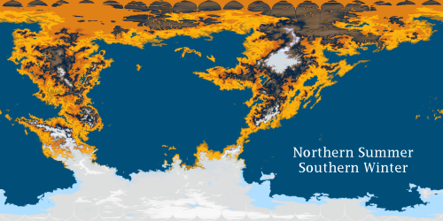
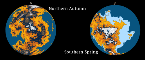
cmaidaartworkblog:cmaidaartworkblog:jayrockin:These truly spectacular maps were created by @cmaidaar
cmaidaartworkblog:cmaidaartworkblog:jayrockin:These truly spectacular maps were created by @cmaidaartworkblog!Centaur HomeplanetStar: K-class, main sequencePosition from star: first Axial tilt: 51 degrees Gravity: 0.85g Terrestrial vegetation: yellow, ocherThe centaur homeplanet has extreme polar seasons because of its 51 degree axial tilt. Most of the settled regions are in the equatorial sweet spot where the sunlight is always oblique, but unlike the poles, it’s not sunless tundra for half the year and nightless desert for the other half. Enormous mountain ranges, taller than most on Earth, divide much of the continent’s interior.The recently formed megacontinent forms a continuous loop around the globe, and nomadic groups walk entire the loop every year. Nightchasers are the groups that follow the planet’s winters, entering the polar areas during their spring seasons. Sunchasers follow the planet’s summers, entering the polar areas during their autumn. The nomads mostly travel along the East Ocean’s coast, so that’s where the most geneflow happens in the settled groups. Nomads themselves are also highly variable in appearance, though they trend towards autumnal camouflage and spring camouflage. Most of the ethnicity names are derived from the names that the Shess call the other groups, since that’s where the majority of alien embassies are on the centaur homeplanet and thus where most of the Jovian English loanwords come from. Note that these are not the same as political regions– because of the clan system, centaur polities are not divided up the same way human polities are. The majority of centaurs living in space are from the nomad ethnic groups. The Shess call them Skychasers. PATREON | Runaway to the Stars I’ve been following this artist and their projects for some time now, and I had a great time working on these maps of one of the many planets that feature in Runaway to the Stars, it was really cool to contribute to it this way : )I rendered these maps in Photopea based on @jayrockin‘s original drafts, and I’m so happy with how they turned out. Definitely go follow Jay here and on Twitter (@JayRock5858) to see more of the project that this belongs to, and all their other works too! They’re really good! A lot of preparation goes into projects like these, part of which is early maps and diagrams like the ones shown here, which demonstrate (respectively) plate tectonics, information about key latitudes, and a representation of seasonal sun exposure and day cycles. -- source link
Tumblr Blog : jayrockin.tumblr.com
#points#rtts centaurs#jayreblogs#long post


